Compartir
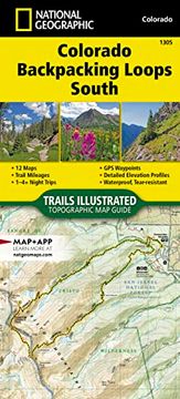
Colorado Backpack Loops South map (National Geographic Topographic map Guide, 1305) (en Inglés)
National Geographic Maps (Autor)
·
National Geographic Maps
· Nuevo
Colorado Backpack Loops South map (National Geographic Topographic map Guide, 1305) (en Inglés) - National Geographic Maps
$ 21.160
$ 38.480
Ahorras: $ 17.320
Elige la lista en la que quieres agregar tu producto o crea una nueva lista
✓ Producto agregado correctamente a la lista de deseos.
Ir a Mis Listas
Origen: Reino Unido
(Costos de importación incluídos en el precio)
Se enviará desde nuestra bodega entre el
Jueves 25 de Julio y el
Lunes 05 de Agosto.
Lo recibirás en cualquier lugar de Chile entre 1 y 3 días hábiles luego del envío.
Reseña del libro "Colorado Backpack Loops South map (National Geographic Topographic map Guide, 1305) (en Inglés)"
- Waterproof - Tear-Resistant - Topographic MapColorado is renowned for its outdoor recreational opportunities. One of these pastimes is, of course, backcountry hiking. The Colorado Backpack Loops South Topographic Map Guide covers a dozen backpack loops selected by National Geographic staff for their diversity, remoteness, and inspiring vistas. Each page of the Topographic Map Guide includes a detailed map of the trail with directions to the trailhead from the nearest major town as well as a trail profile with mileages to foreshadow the elevation changes that will be met along the way. GPS coordinates are also provided for strategic points along the trail to help with navigation.The trails are organized by the number of nights backpackers can expect to be in the backcountry, from one to more than three. They range from 10 to 26 miles long with elevation gains from 2,000 to over 9,000 feet. Written descriptions of each trail give an overview of the natural features that will be encountered along the way as well as the length, total elevation gain, and nearest town to each trailhead. This Topographic Map Guide will get you into the wild lands of southern Colorado that most hikers in the country can only dream about.More convenient and easier to use than folded maps, but just as compact and lightweight, National Geographic's Topographic Map Guide booklets are printed on "Backcountry Tough" waterproof, tear-resistant paper with stainless steel staples. A full UTM grid is printed on the map to aid with GPS navigation.Map Scale = 1:40,680 & 1:63,360Folded Size = 4.25" x 9.38"
- 0% (0)
- 0% (0)
- 0% (0)
- 0% (0)
- 0% (0)
Todos los libros de nuestro catálogo son Originales.
El libro está escrito en Inglés.
La encuadernación de esta edición es Nuevo.
✓ Producto agregado correctamente al carro, Ir a Pagar.

